please format code with </> button * homework policy * asking questions
Hi Everyone,
I want to scan in 3D and mill these with CAM.
I have access to some nice tools to do so:
- Livox Mid-40 LiDAR
- Fusion 360 and its CAM tools
- production CNC lathe with milling tools
My idea is to do following steps:
- get .csv from the lidar with its point cloud
- calculate a height map from these points
- use blender with the displacement on a plane to create a 3d model (soft modelled)
- import the soft model into Fusion 360 and generate CAM toolpaths
- mill it on the CNC
What i achieved so far:
- scan with the lidar:
- use processing to calculate the heightmap:

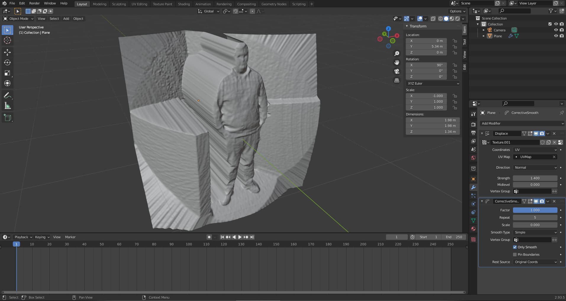
- use blender for the model:

Code for processing:
ArrayList<scanPoint>scanPoints = new ArrayList<scanPoint>();

float minX = 0;
float maxX = 0;
float minY = 0;
float maxY = 0;
float minZ = 0;
float maxZ = 0;

float overrideMaxZValue = 1.8;
boolean overrideMaxZ = false;

int counter = 0;
int calculatedPixels = 0;
int calculationStarted = 0;

PImage heightmap;

boolean calculating = false;

void setup(){
  size(500,500,P2D);
  heightmap = new PImage(width,height);
  parseFile();
}

void draw(){
  if(!calculating){
    image(heightmap,0,0);
  }
  else{
    background(0);
    text("Calculated pixels: " + calculatedPixels + " of: "+ (width*height),10,10);
    float percentage = (float(calculatedPixels)/( float(width) *float(height)))*100;
    text(nf(percentage,0,3) + "%",10,30);
    float seconds = (millis()-calculationStarted)/1000;
    float minutes = seconds/60;
    float hours = minutes/60;
    text("Time since calculation start: "+int(hours) + ":"+int(minutes%60)+ ":"+int(seconds)%60,10,50);
    float eSeconds = (100/percentage)*(millis()-calculationStarted)/1000;
    float eMinutes = eSeconds/60;
    float eHours = eMinutes/60;
    text("Estimation: "+int(eHours) + ":"+int(eMinutes%60)+ ":"+int(eSeconds)%60,10,70);
  }
}

void mouseClicked(){
  if(mouseX > 0 && mouseX < width && mouseY > 0 && mouseY < height && mouseButton == LEFT){
    calculating = true;
    calculationStarted = millis();
    thread("drawHeightmapFilled");
  }
  else if(mouseButton == RIGHT){
    heightmap.save("C:/Users/***/Desktop/Privat/heightmaps/heightmap from livox scan.png");
    println("saved heightmap");
  }
}

void drawHeightmapSimple(){
  println("start drawing heightmap");
  for(int i = 0; i<scanPoints.size();i++){
    scanPoint sp = scanPoints.get(i);
    float pX = map(sp.pX,minX,maxX,width,0);
    float pY = map(sp.pY,minY,maxY,height,0);
    int whiteValue = int(map(sp.pZ,minZ,maxZ,255,0));
    color pZ = color(whiteValue,whiteValue,whiteValue);
    heightmap.set(int(pX),int(pY),pZ);
    calculatedPixels ++;
  }
  println("done drawing heightmap");
  calculating = false;
}

void drawHeightmapFilled(){
  println("start drawing heightmap");
  for(int X = 0; X<width;X++){
    for(int Y = 0; Y<height;Y++){
      float distance = 9000;
      color pZ = color(0,0,0);
      for(int i = 0; i<scanPoints.size();i++){
        scanPoint sp = scanPoints.get(i);
        float pX = map(sp.pX,minX,maxX,width,0);
        float pY = map(sp.pY,minY,maxY,height,0);
        float bufferDistance = dist(X,Y,pX,pY);
        if(bufferDistance<distance){
          distance = bufferDistance;
          if(sp.pZ < minZ || sp.pZ > maxZ){
            pZ = color(255,0,0);
          }
          else{
            int whiteValue = int(map(sp.pZ,minZ,maxZ,255,0));
            pZ = color(whiteValue,whiteValue,whiteValue);
          }
        }
      }
      heightmap.set(X,Y,pZ);
      calculatedPixels ++;
    }
  }
  println("done drawing heightmap");
  calculating = false;
}

void parseFile() {
  BufferedReader reader = createReader("C:/Users/***/Desktop/Privat/heightmaps/kopfscan.csv");
  String line = null;
  try {
    while ((line = reader.readLine()) != null) {
      String[] coord = split(line, ",");
      float Xa = stringToFloat(coord[14]);
      float Ya = stringToFloat(coord[15]);
      float Za = stringToFloat(coord[13]);
      float Z = dist(0,0,0,Xa,Ya,Za);
      float X = tan(Xa/Za);
      float Y = tan(Ya/Za);

      if(X>maxX)maxX = X; else if(X<minX) minX = X;
      if(Y>maxY)maxY = Y; else if(Y<minY) minY = Y;
      if(Z>maxZ)maxZ = Z; else if(Z<minZ) minZ = Z;
      if(counter == 1){
        minX = X;
        maxX = X;
        minY = Y;
        maxY = Y;
        minZ = Z;
        maxZ = Z;
      }
      if(!Float.isNaN(X) && !Float.isNaN(Y) && !Float.isNaN(Z)){
        scanPoints.add(new scanPoint(X,Y,Z));
      }
      counter++;
    }
    reader.close();
  } catch (IOException e) {
    e.printStackTrace();
  }
  if(overrideMaxZ) maxZ = overrideMaxZValue;
  println("maxX: "+maxX+" ||minX: "+minX);
  println("maxY: "+maxY+" ||minY: "+minY);
  println("maxZ: "+maxZ+" ||minZ: "+minZ);
  println("number of points: "+counter);
}

class scanPoint{
  float pX = 0;
  float pY = 0;
  float pZ = 0;

  scanPoint(float x, float y, float z){
    pX = x;
    pY = y;
    pZ = z;
  }
}

Float stringToFloat(String str){
  float buffer = 0;
  buffer = float(str);
  if(Float.isNaN(buffer)){
    if(str.equals("true")){
      buffer = 1;
    }
    else{
      buffer = 0;
    }
  }
  return buffer;
}
I have got two problems with my code:
- I do have a curvature error and i think it comes from the perspective view which i calculated in the parseFile() function. A Orthographic view would make more sense for the displacement in blender but then i do have point shadows and overlapping geometry.
- It takes a long time to calculate the heightmap. A scan has ~300k points. I calculate for each pixel the distance to the nearest point and save its Z value. An image of 500x500 takes about 15 minutes. I seperated it into a second thread to show its progress in the draw function. Do i have to seperate the image into even more threads or would CUDA make sense?
I would appreciate any suggestion or comment.
Kind regards,
StainlessHolz


 . I have just to use the original XYZ values and ignore overlapping geometry.